


Land development is a high-stakes game of precision. Whether it’s a residential subdivision, a commercial complex, or an industrial facility, the difference between a profitable project and a financial disaster often lies in the dirt—specifically, understanding exactly what is happening on (and under) the ground before a single shovel hits the earth. In the past, developers relied on rough surveys and paper maps that could be months or even years out of date. Today, the margin for error has shrunk significantly. Regulatory hurdles are higher, environmental constraints are tighter, and the need for efficiency is greater than ever.
The solution lies in the convergence of data and geography. Accurate mapping is no longer just about drawing property lines; it is about creating a comprehensive digital twin of the site that informs every decision from feasibility to final construction. By leveraging modern geospatial technologies, developers can visualize potential pitfalls, optimize land use, and streamline the approval process.
Here are five key ways advanced mapping techniques are driving smarter, more efficient land development.
1. Utilizing GIS for Site Selection and Analysis

Geographic Information Systems (GIS) act as the central nervous system for modern land planning. While traditional maps provide a static view of a location, GIS allows developers to layer multiple datasets on top of one another to reveal relationships that aren’t visible to the naked eye. This might include overlaying zoning restrictions with flood plain data, soil composition, and existing utility infrastructure.
By integrating these disparate data points, project managers can perform complex site suitability analyses in a fraction of the time it used to take. For instance, a developer looking for a site for a new retail center can use GIS to filter locations based on traffic counts, demographic density, and distance from competitors. However, the complexity of these datasets often requires specialized expertise to interpret correctly. This is where professional GIS consulting services become invaluable, helping organizations model various scenarios to predict how a site will perform under different conditions. This analytical power transforms raw data into actionable intelligence, allowing for safer, more informed investment decisions.
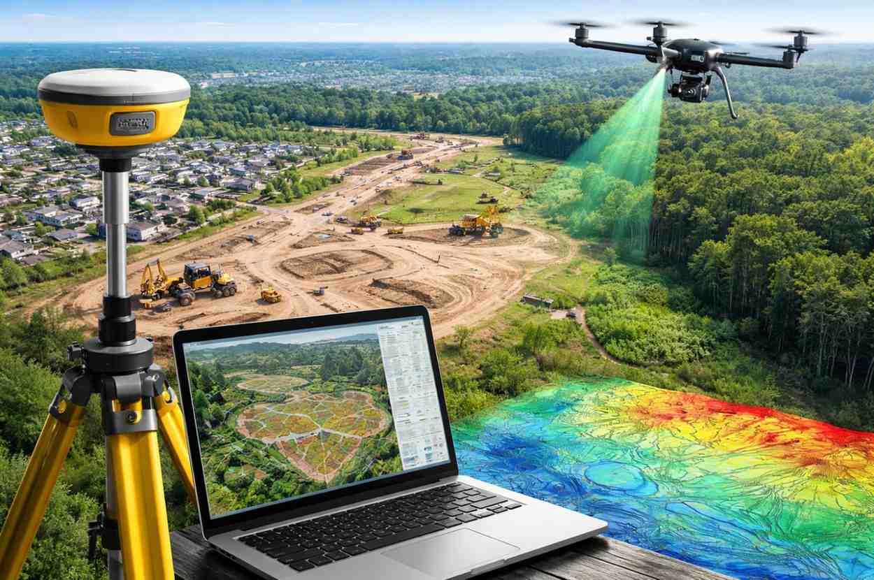
2. Employing LiDAR Technology for Detailed Terrain Mapping
Understanding the topography of a site is critical for engineering and drainage planning, but traditional surveying methods can be slow and labor-intensive, especially on large or heavily vegetated tracts of land. Light Detection and Ranging (LiDAR) has revolutionized this process by using laser pulses to generate precise, three-dimensional information about the shape of the Earth and its surface characteristics.
LiDAR sensors, often mounted on aircraft or drones, can penetrate canopy cover to map the ground beneath trees, a feat that photogrammetry alone cannot achieve. This results in a highly accurate Digital Elevation Model (DEM) that engineers use to calculate cut-and-fill volumes with extreme precision. For a developer, this means more accurate budget estimates for earthworks. If a site requires moving 50,000 cubic yards of dirt versus 100,000, the cost implications are massive. LiDAR data helps eliminate the guesswork, ensuring that the engineering designs align perfectly with the actual terrain, reducing the risk of costly change orders during grading.
3. Integrating Drone Imagery for Real-Time Monitoring
Unmanned Aerial Vehicles (UAVs), or drones, have moved beyond being hobbyist gadgets to become essential tools on the construction site. While satellite imagery is useful for a macro view, it often suffers from low resolution and lag time—the image you see on Google Earth might be two years old. Drones bridge this gap by providing high-resolution, real-time aerial imagery that captures the site’s current condition.
By conducting regular drone flyovers, developers can create orthomosaic maps—highly detailed images corrected for perspective and scale—that serve as a source of truth for project progress. These maps allow stakeholders to monitor construction milestones remotely, verify that materials are being staged correctly, and identify safety hazards before they become accidents. Furthermore, comparing drone imagery over time creates a visual timeline of the project, which is invaluable for stakeholder reporting and resolving disputes with contractors regarding work completion.
4. Conducting Thorough Ecological Assessments

Land development rarely happens in a biological vacuum. Projects near coastlines, wetlands, or waterways face a complex web of environmental regulations designed to protect sensitive ecosystems. Integrating ecological data into the mapping process is essential for compliance and sustainability. This is particularly true for projects with a marine or riparian component, where the interaction between land and water is dynamic.
Detailed mapping of marine and wetland environments helps identify critical habitats, such as seagrass beds or spawning grounds, that must be avoided or mitigated. By consulting on marine ecology factors early in the planning phase, developers can design site layouts that minimize environmental impact, such as incorporating buffer zones or designing stormwater management systems that prevent harmful runoff. This proactive approach not only facilitates smoother regulatory approvals but also enhances the long-term resilience of the development against issues like erosion and sea-level rise.
5. Implementing GPS for Precise Boundary and Feature Mapping
While remote sensing tools like drones and LiDAR provide the big picture, Global Positioning System (GPS) technology provides the pinpoint accuracy needed on the ground. Modern survey-grade GPS (often enhanced by Real-Time Kinematic or RTK systems) allows surveyors to locate boundaries, utilities, and infrastructure with centimeter-level precision.
This level of accuracy is non-negotiable when staking out property lines, building corners, or road alignments. Inaccurate boundary mapping can lead to severe legal and financial consequences, including encroaching on neighboring properties or violating setback requirements. Beyond boundaries, GPS is increasingly used for machine control, where heavy equipment like bulldozers and graders are guided automatically by 3D site models. This ensures that the physical construction matches the digital design exactly, reducing rework and accelerating the construction schedule.
The Future of Smart Development
The era of developing land based on intuition and rough sketches is over. As land becomes scarcer and regulations more stringent, the industry is shifting toward a model where data dictates design. By weaving together technologies like GIS, LiDAR, drones, and GPS, developers can build a foundation of accuracy that supports every subsequent phase of a project. These tools do more than just map the land; they de-risk the investment, ensuring that what is built is safe, compliant, and profitable. Embracing these advanced mapping techniques is not just about keeping up with technology—it is about building smarter for the future.